Background:
 South Fork Mountain Spring is a naturally occurring fresh water spring located on a 326-acre parcel in the foot hills of the Mad River Mountain Range, in Trinity County, California. It is situated between the boundaries of the Six Rivers National Forest and the Trinity Wilderness. This spring is the source of water for the South Fork Mountain Spring Water Company. There wasn’t any environmental exploration information that characterizes the collection system or catchment area that supplies the spring.
Objectives:
- Collect 2D and 3D images of the collection/catchment area using non-destructive ground penetrating radar.
- Evaluate and process theses images to resolve to isolate, then report the characteristics of the collection/catchment area.
Findings
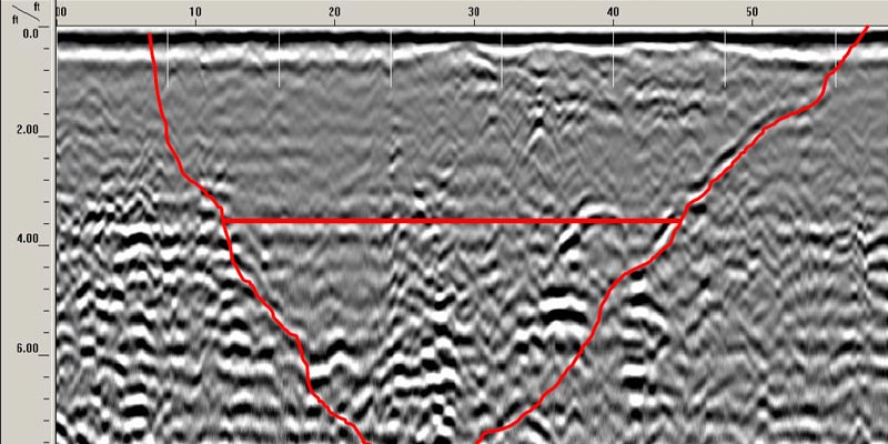
Profile 033 is a linear file running down slope directly in line with and stopping at the hatch outlet. The linear orientation of the catchment trench is out lined in red. The catchment area is 25’ + in length. The horizontal red line depicts the water level interface.
The collection system for this spring consists of a linear trench described above that has been backfilled with small round cobble and a coiled perforated pipe. This coiled perforated pipe carries the spring water in a zigzag fashion down the slope to a smaller galvanized pipe that is controlled by a valve at the hatch. As shown below, the pipe is concentrated in a spring well up the slope from the hatch.

The environmental exploration of this area showed a large cavity filled with rock or other porous material bedded with coiled perforated pipe overlapping each other vertically much like the shape of a bee hive. The black white black banding is indicative of the dielectric interface of energy changing from negative to positive to negative. The 3D image below of our environmental exploration depicts a large circular cone shape built by successive layers of air/water filled cavities.


